


-
空间激光测高载荷向地球或其他星体表面发射激光脉冲,通过测量星体表面散射信号与发射激光脉冲的时间差,结合载荷的高精度姿态及位置数据,实现足印点三维坐标的高精度获取。激光测高载荷能实现亚纳秒级时间测量,激光的波束相对更窄,在测距精度和空间分辨率上远优于微波载荷,可获取更精细的地面高程信息。除距离外,空间激光测高载荷还能获取目标的反射率、退偏特性等信息,实现目标的多参数获取。
自1971年阿波罗计划首次在空间探测中开展月球表面激光探测后[1],空间激光测高技术被被广泛应用于地球及太阳系其他星体探测领域,文中主要阐述该领域的重要进展及技术发展趋势,将对空间激光测高技术国内外发展现状、典型载荷进行描述,梳理空间激光测高的技术发展过程,对空间激光测高关键技术及其发展需求进行分析,并对未来发展进行展望。
-
空间激光测高主要依赖于脉冲激光测距技术的发展,其发展历史可以追溯到1962年,Mc Clung和Hellwarth发明调Q脉冲激光器[2],产生峰值功率足够高的巨脉冲激光,使得远距离飞行时间脉冲激光测距成为可能。调Q脉冲激光技术发明后即被应用于远距离测量,并于1971年随阿波罗15号开展首次空间应用,1971~1972年,阿波罗15-17号利用搭载在指令舱的红宝石脉冲激光器,开展多次绕月激光测距探测[1, 3],但由于技术限制,当时开展探测的激光器每20 s才发射一次激光脉冲,导致探测效率极低,3次搭载激光测高载荷的阿波罗探月任务,仅获取了几千次月球表面高程数据。20世纪90年代,随着激光器技术的进步,尤其是半导体泵浦技术极高提高了激光器的重复频率和寿命,飞行时间脉冲激光测距技术在空间探测领域中得到快速发展。1971年至今,国内外发射了大量的空间激光测高载荷(表1),大部分由美国国家航空航天局(NASA)主导,探测目标包括地球、月球、火星、小行星等,如2003年NASA发射的冰、云、陆地高程探测卫星搭载的GLAS地球科学激光测高系统[4]、NASA于2009年成功实施的月球勘测轨道飞行器(LRO)任务上首次搭载的多波束对月激光测高仪(LOLA)[5]、NASA于2018年成功实施的冰、云、陆地高程探测卫星二代上搭载的ATLAS先进地形测高系统[6-7]等。
表 1 1970~2019年国内外空间激光测高载荷发展历史
Table 1. Development history of space laser altimetric payloads at home and abroad from 1970 to 2019
Launch time Country Payload Space-based platform Major mission 1971-1972 USA Lunar laser altimetry Apollo 15-17 The world’s first lunar surface elevation measurement mission. Limited by the laser technology, only several thousand measurements were taken during the three missions 1992 USA Mars observer laser altimeter Mars observer This mission was planned to measure the Mars surface elevation. But the satellite was failed to enter the Mars orbit 1994 USA Lunar laser altimetry Mentine orbiter The world’s first lunar surface elevation measurement mission 1996-1997 USA Shuttle laser altimeter STS-72 The SLA mission carried out twice space laser altimetry experiments, acquired about 80 hours data, and established a global elevation control point database for the first time 1996 USA Mars orbiter laser altimeter Mars Global Surveyor The world's first successfully Martian elevation measurement mission 2003 USA Geoscience Laser Altimeter System Ice, cloud,and land elevation satellite World's first laser altimetry system for long-term continuous observation of the earth 2003 Japan Laser altimetry Hayabusa spacecraft The system successfully detected the three-dimensional shape of the Itokawa asteroid at 2005 2004 USA Mercury laser altimeter MESSENGER spacecraft The spacecraft entered the orbit of Mercury at 2011 and carried out three-dimensional survey of the northern hemisphere of Mercury during the observation period of one earth year 2007 China Laser altimeter Chang’e-1 China firstly carried out the lunar elevation observation. The payload acquired more than 9 million measurements until 2009 2007 Japan Laser altimeter SELENE satellite Japan firstly carried out the lunar elevation observation. 2008 India Lunar Lnging Instrument Chandrayaan-1 India firstly carried out the lunar elevation measurement. 2009 USA Lunar orbiter laser altimeter Lunar reconnaissance orbiter The 5-beam design is used to obtain the highest resolution 3D topographic map of the lunar surface so far. 2010 China Laser altimeter Chang’e-2 The second lunar elevation measurement program by China. 2013 China Laser three-dimensional imaging sensor Chang’e-3 The payload quickly scanned the lunar terrain at the final stage of Chang’e-3 soft landing. 2016 China Laser altimter Ziyuan-3 (02) satellite The first space-based lidar observation of earth surface elevation by China. 2018 USA Advanced topographic laser altimeter system Ice, cloud,and land elevation satellite-2 The world’s first photon counting lidar for earth surface elevation measurement. ATLAS largely improved the elevation measurement efficiency than previous space-based laser altimeter. It also has the ability to measure the atmospheric aerosol and clouds 2018 USA Global ecosystem dynamics investigation International space
stationISS-based lidar altimeter for forest observation with repetition rate of 242 Hz to achieve nearly successive laser footprint observation 2018 China Laser three-dimensional imaging sensor Chang’e-4 The terrain scanning lidar is used for the first Lunar backside soft landing 2019 China Laser altimeter GF-7 The laser altimeter was used for accurate elevation control points measurement of 3D surveying and mapping satellite 中国空间激光测高技术起步较晚,但也在嫦娥探月工程及高分辨率对地观测计划中得到了充分应用。嫦娥一号到四号均搭载了激光测高载荷,开展工程或者科学应用;2019年,高分七号卫星成功发射,其上搭载的激光测高分系统成功开机并获取数据,为中国立体测绘卫星地面高程控制点提供精确的三维坐标数据。下文将重点对国内外典型空间激光测高载荷进行描述。
-
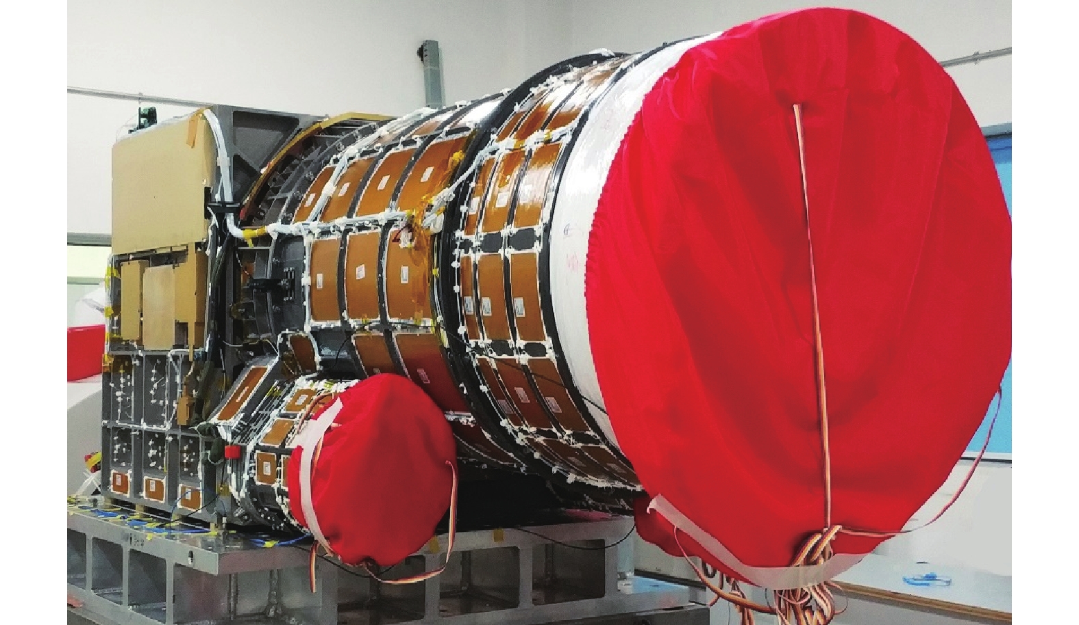
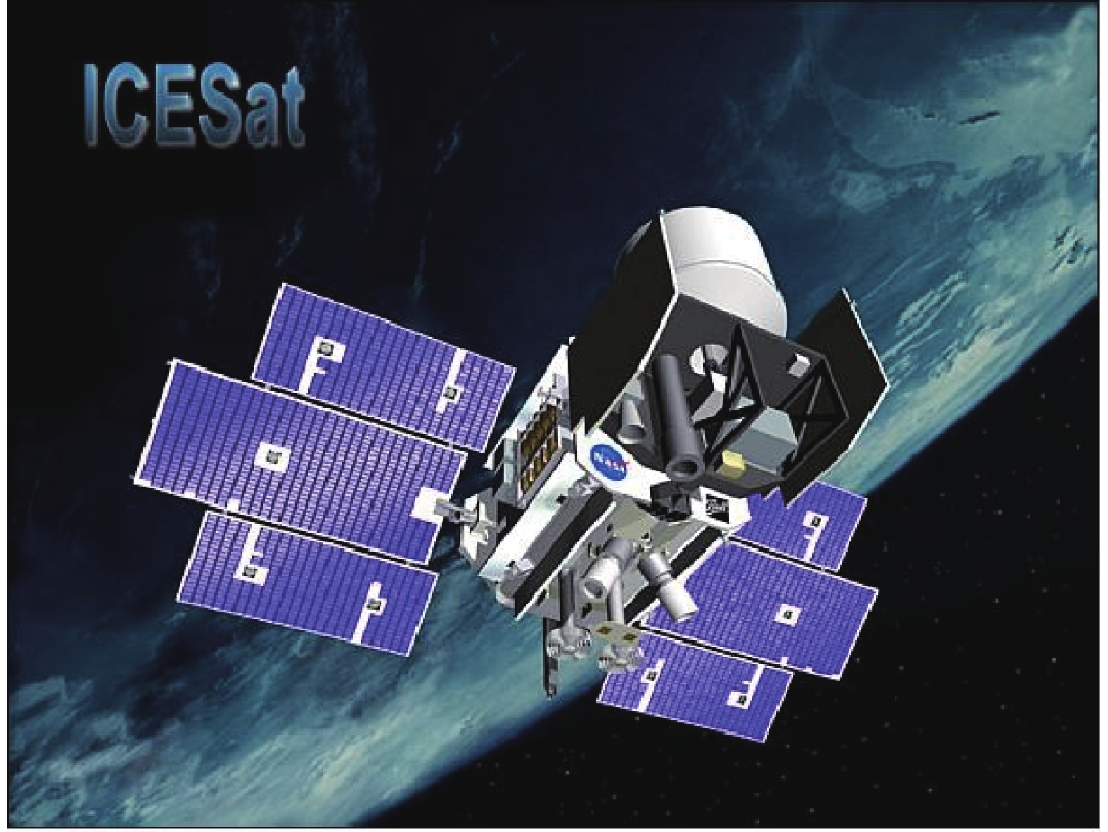
GLAS地球科学激光高度计是首个开展长期地球表面高程探测的载荷,搭载于2003年发射的冰、云、陆地高程卫星(图1)上(ICESat: Ice, Cloud and land Elevation Satellite),是美国于20世纪80年代制定的地球观测系统(EOS: Earth observation system)的一部分。ICESat卫星轨道高度大约600 km,GLAS载荷配备3台激光器,其中2台为备份激光器,GLAS开机后仅工作36天,其第一台激光器即由于故障原因停止工作,为了保证针对南北极冰盖厚度变化这一主要科学目标的正常实施,GLAS每年仅开展3次观测,每次观测持续30~50天,以保证激光器在载荷科学目标达成前仍能正常工作。

图 1 冰、云、陆地高程卫星
Figure 1. Satellite of ICESat
GLAS载荷的主要科学任务包括:(1)测量地球南北极冰盖高程,研究冰川消融对海平面变化的影响;(2)利用532 nm波段激光,测量云和气溶胶的垂直结构,获取云顶和云底高度、云后向散射系数垂直廓线、薄云的光学厚度等信息;(3)测量冰面高度、陆地地形和森林植被的树冠高度,获取全球尺度的地表粗糙度、反射率、植被高度等特征。
GLAS的激光器采用二极管泵浦调Q结构,同时输出1 064 nm基频和532 nm倍频激光脉冲,单脉冲能量分别为75 mJ和32 mJ。GLAS利用Nd:YAG激光器的1064 nm基频光开展地表高程探测,采用全波形探测体制,可以获取陆地表面植被的垂直分层信息,实现树冠和地表高程的同时探测,借助于高精度激光指向测量技术,GLAS可以实现在地面坡度小于3°的情况下10 cm的测距精度。GLAS计划利用532 nm激光开展气溶胶、云垂直分布廓线的探测,但是由于倍频模块的不稳定性,其532 nm激光能量迅速降低,因此其针对大气的探测任务并未顺利实施。
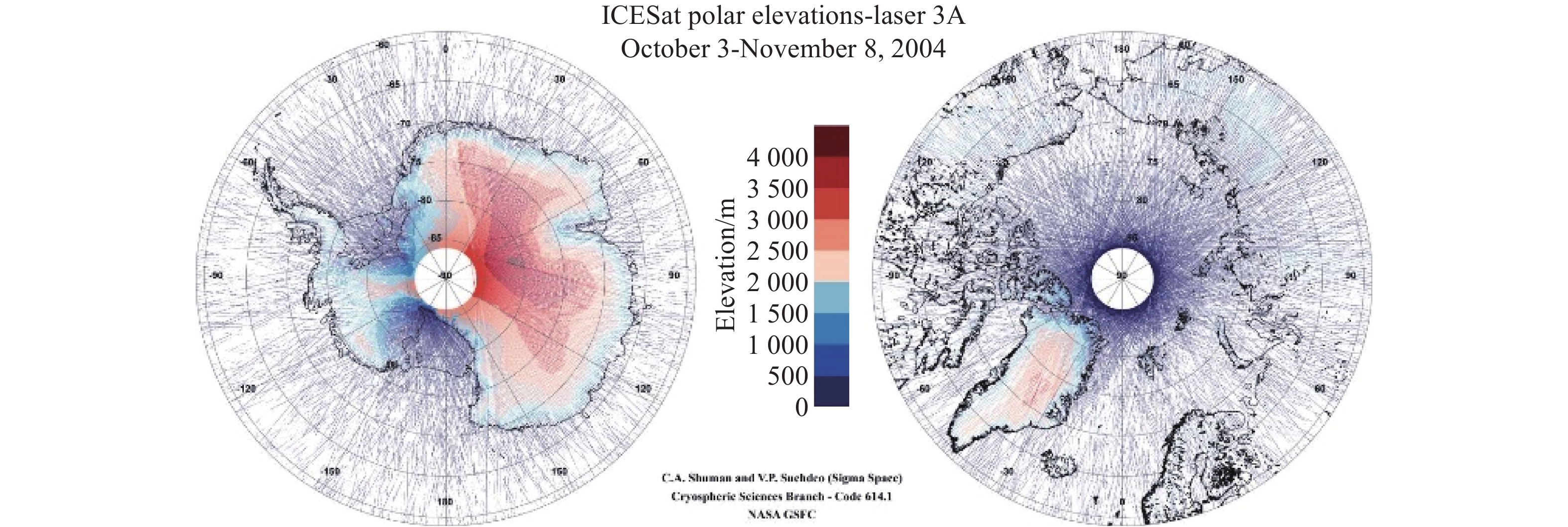
图2展示了一个观测周期内,GLAS观测的南北极高程结果,利用GLAS的长期测量数据,研究人员展示了全球变暖导致的北极海冰消融趋势[8]。随着最后一台激光器停止工作,GLAS载荷的任务在2009年10月终止。GLAS载荷为美国后续空间激光任务积累了大量经验,NASA后续空间激光探测任务中,激光器的稳定性得到大幅度提升,例如,2006年发射的CALIPSO激光大气探测卫星,其激光器与ICESat卫星均由Fibertek公司提供,CALIPSO卫星激光雷达的寿命远超GLAS,从发射在轨运行至今仍在正常采集数据。
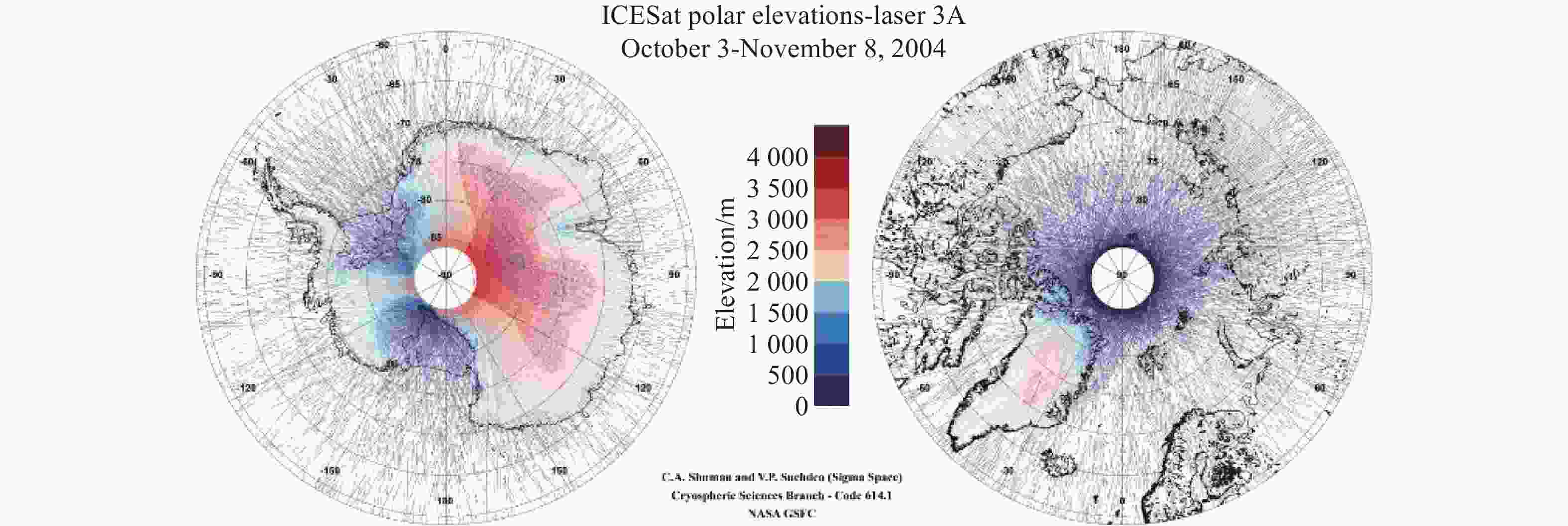
图 2 ICESat一次观测周期得到的典型南北极探测结果
Figure 2. Typical results at north and south poles obtained in one observation period of ICESat
-
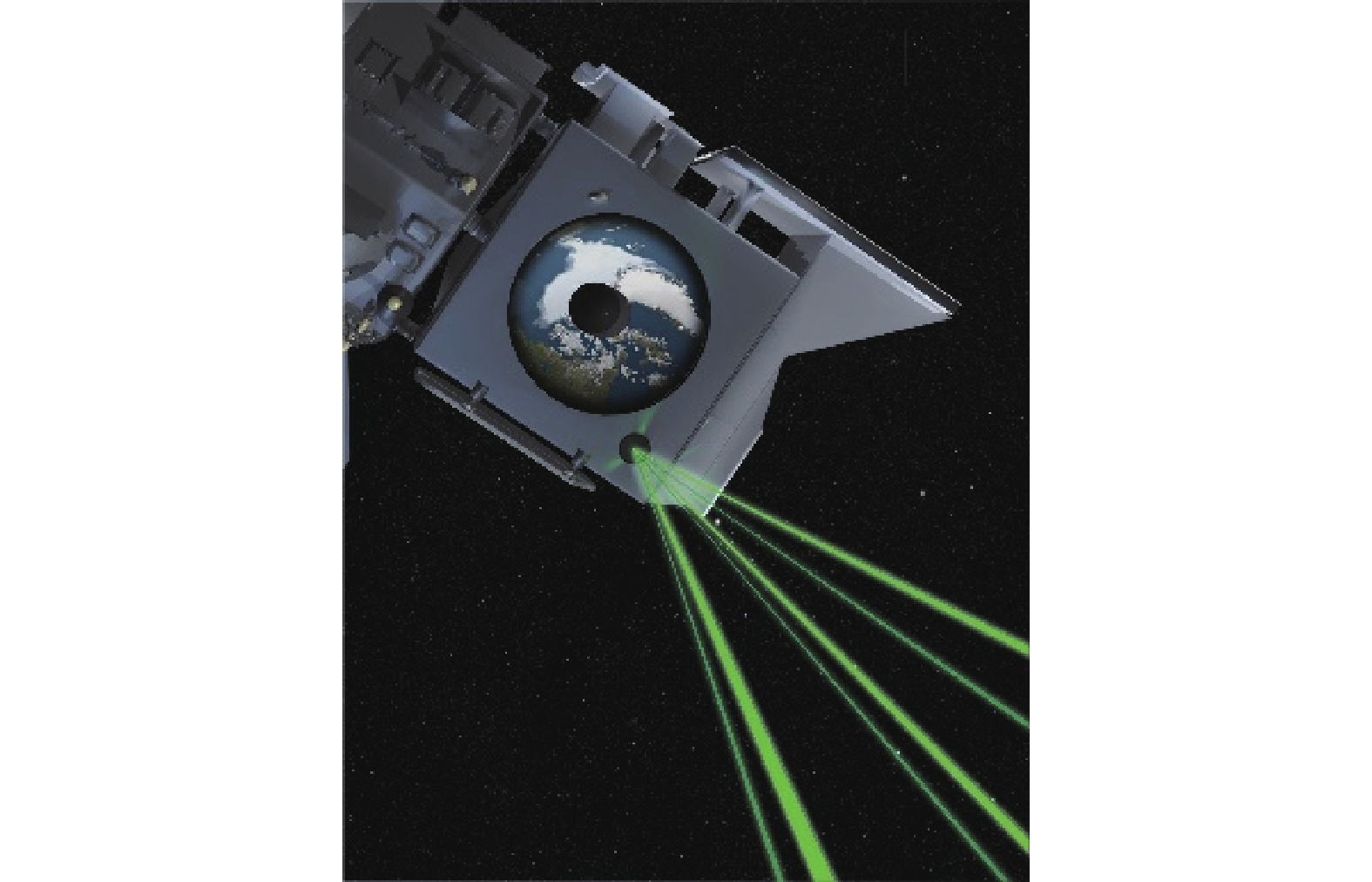
ATLAS是世界上首个基于单光子探测技术的空间激光测高载荷,于2018年9月搭载于ICESat-2卫星发射升空,卫星工作于500 km公里圆形轨道,ATLAS工作于Nd:YAG激光器的二倍频(532 nm),这样可以用更为成熟的光电倍增管开展单光子探测,激光重复频率也提高到10 kHz,这样相邻激光足印的间距不超过1 m,可以实现近乎连续的星下激光足印测量,提高地形、植被、树冠点云数据的密度[7, 9]。ATLAS的激光器脉冲宽度大约1.5 ns,对单光子探测体制下测距精度的提高具有重要意义,采用了大量先进的技术,倍频效率高达70%,整体电光转换效率也高达8.2%,有利于降低激光器功耗,减小卫星资源需求,实现多波束对地探测。如图3所示。

图 3 ICESat-2卫星对地观测效果图
Figure 3. Earth observation renderings of ICESat-2
ATLAS由于采用光子探测体制,单波束能量仅40~170 μJ即实现500 km距离下的对地测距。载荷设计了6个波束(图4),分为三个强能量波束和三个弱能量波束,以适应不同反射率目标的测量,提高反射率的定量反演精度。
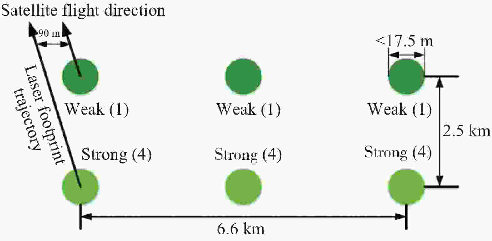
图 4 ICESAT-2卫星激光载荷地面激光足印分布
Figure 4. Ground laser foorprint distribution of laser payload on ICESat-2
ATLAS所工作的532 nm波段还具备一定的水体穿透能力,能对部分浅水区域水底高程进行探测。图5为星下足印从山坡到水下的ATLAS原始单光子点云数据,该数据清晰地展示了被植被覆盖的陆地表面、海面、浅滩水底的地形变化,还展现了海洋波浪的周期性形态特征。ATLAS的水深测量能力受限于水体衰减及散射特征、水底地物反射率,从数据上来看,ATLAS最大实现了超过30 m水深的测量[9]。

图 5 ATLAS的典型单光子点云数据
Figure 5. Typical single photon point cloud data of ATLAS
-
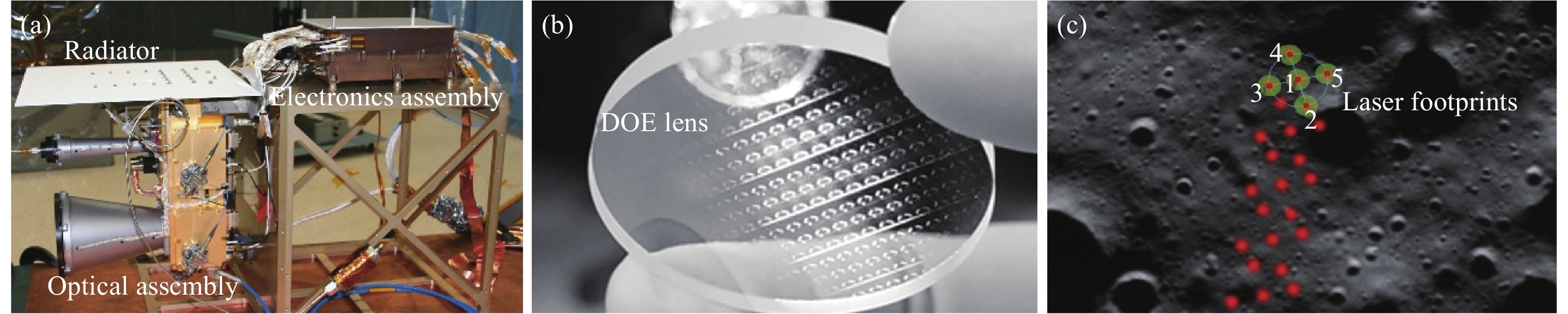
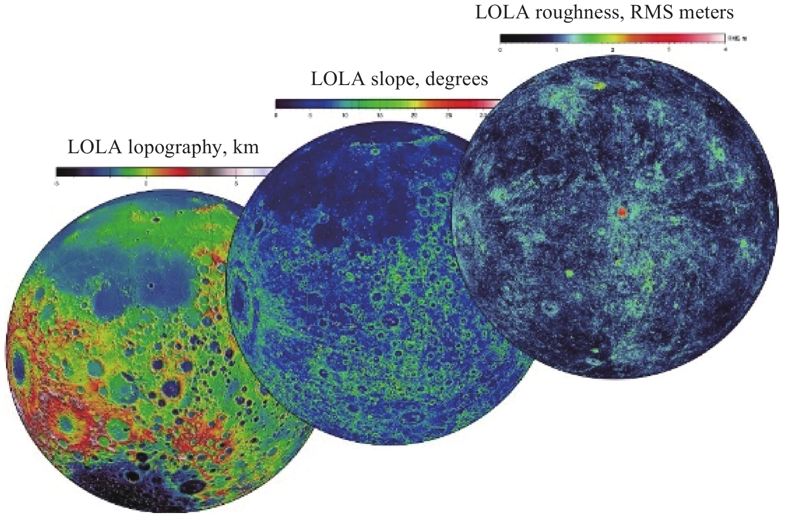
LOLA是世界上第一个在月球轨道上开展多波束月表高程探测的载荷,它于2009年6月18日搭载于美国发射的月球勘测轨道飞行器(LRO)上升空[5],LOLA同样工作于1 064 nm波段,轨道高度50 km,利用衍射光学器件将激光分为5个不同方向的波束,在提高点云数据获取率的同时,还可以实现月表斜率、粗糙度等信息的获取。LOLA在接收系统焦平面采用阵列探测器接收回波信号。图6展示了LOLA的主体结构、衍射光学器件及月表激光足印分布,LOLA所获取的高程、反射率、粗糙度、斜率等信息,可以反映不一样的月面特征,LOLA获得了迄今为止最清晰的月面三维高程图。图7为月球勘测轨道飞行器上搭载的月球激光测高仪测得的不同参数的分布。

图 6 LOLA系统组成(a)、核心DOE分光器件(b)及月面足印分布示意图(c)
Figure 6. System compositions (a), key multi-beam generation DOE component (b) and foorprint distribution on lunar surface (c) of LOLA
-
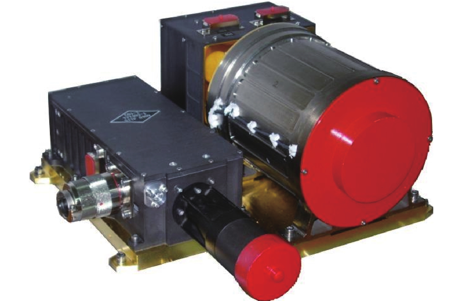
嫦娥一号和二号上均搭载了激光高度计[10](图8),实现了我国空间激光测高载荷的首次空间应用。嫦娥1/2号激光高度计由中国科学院上海技术物理研究所研制,工作于Nd:YAG激光器的1064 nm基频光,单脉冲能量150 mJ,月表光斑直径大约600 m。月面回波由直径134 mm望远镜接收,经窄带滤光片滤除大部分太阳背景辐射后,汇聚至雪崩光电二极管,再经阈值检测电路实现月面高程直接获取,嫦娥1/2号搭载的激光高度计具备以5 m精度(3σ置信度)实现月球表面高程探测的能力。利用嫦娥1号激光高度计的数据,我国首次实现了月表DEM的高精度获取(图9),为后续嫦娥系列着陆任务的选址提供了基本数据。

图 8 嫦娥1号激光高度计
Figure 8. Laser altimetry aboard on Chang’e-1 lunar satellite
图 9 嫦娥一号激光高度计探测的全月面DEM图
Figure 9. Observed lunar DEM map by laser altimetry aboard on Chang’e-1 lunar satellite
-
资源三号02星是资源三号系列卫星的第二颗,于2016年5月发射,搭载我国首个对地激光测高试验载荷[11],开展线性探测体制下的对地测距应用。载荷工作于1064 nm,激光脉冲宽度大约6.5 ns,单脉冲能量175 mJ,有效接收孔径210 mm,卫星轨道高度505 km,与嫦娥1/2号激光测高仪一样,采用阈值检测方式实现地球表面高程探测。资源三号02星激光测高载荷经在轨检校后,在小于2°坡度情况下,平面定位精度优于15 m,高程精度优于1.0 m[12]。
-
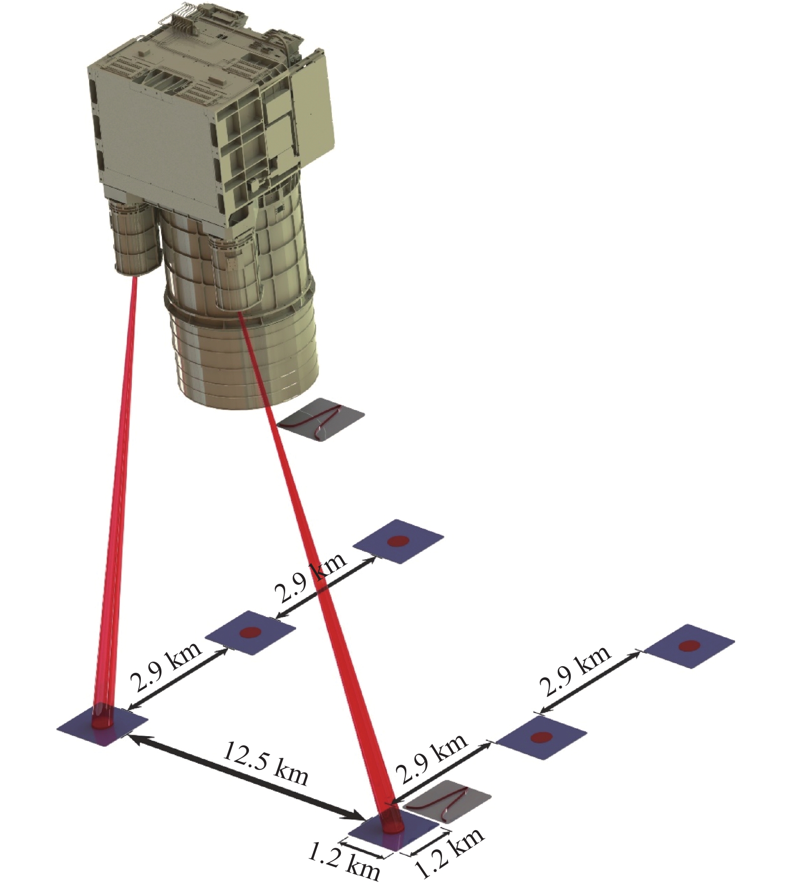
高分七号是我国第一颗应用于开展天基对地立体测绘的卫星,它的主载荷包括双线阵立体相机和激光测高仪,中国科学院上海技术物理研究所负责开展激光测高仪的研制,该载荷具备2个波束的激光测高能力,其获取的地表高程数据,能为双线阵立体相机提供高精度控制点,为基于摄影测量学的立体测绘提供绝对高程参考。图10为高分七号激光测高仪的整体结构,它的发射系统包括4台配置激光扩束系统的Nd:YAG激光器,采用2主2备的形式,在任意时刻均有2台激光器同时工作,搭配接收系统中的两个方向信号采集系统,实现双波束对地激光测高。

图 10 高分七号卫星有效载荷
Figure 10. Payload of GF-7
高分七号激光测高仪2个波束角度大约1.4°,对应地面激光足印间距大约12.5 km,激光重复频率3 Hz,采用0.6 m的望远镜接收地球表面回波信号,图11展示了地面激光足印分布。高分七号采用全波形探测体制,相比我国之前空间激光测高载荷开展的阈值检测测距方式,它能对地表附近的回波进行高速采样,采样率达到2 GSps,可以分辨激光落点区域的树冠、地面、建筑等信息,全波形探测获取的树高数据,能为森林生态系统研究提供数据。全波形探测在数据后处理上更加灵活,利用波形分解技术,可以实现足印下多目标的同时探测。高分七号激光测高仪,对我国开展全球范围内1∶1万比例尺测绘奠定基础。
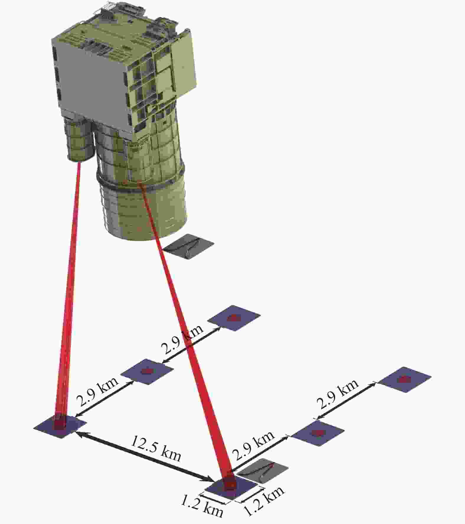
图 11 高分七号卫星激光足印分布示意图
Figure 11. Laser footprint distribution of GF-7 satellite
-
表2列出了目前成功实施的空间激光测高任务的主要技术指标,从探测目标来看,目前的空间激光测高载荷主要针对地球于太阳系其他星体表面高程测量任务开展,利用卫星对地形的不断重复探测,通过长时间的数据累积来实现全星球尺度的高程获取,或者通过对卫星的高精度轨道控制,来实现高精度的足印重返,为长时间尺度全球变化研究提供可对比的长期观测数据。
表 2 国内外已成功实施的部分空间激光测高载荷主要技术指标
Table 2. Major technical specifications of some laser altimetry payloads that have been successfully implemented at home and abroad
Payload GLAS Laser altimeter LOLA Laser altimeter ATLAS Laser altimeter Launch time 2003 2007/2010 2009 2016 2018 2019 Platform ICESat Chang’e-1/2 LRO Ziyuan-3(02) ICESat-2 GF-7 Observation Earth surface elevation Lunar surface elevation Lunar surface elevation Earth surface elevation Earth surface elevation Earth surface elevation Orbit height 600 50 50 505 500 500 Telescope diameter/m 1.0 0.13 0.15 0.21 0.8 0.6 Laser wavelength/nm 1 064/532 1 064 1 064 1 064 532 1 064 Laser repetition rate/Hz 40 1-5 28 2 10 3 Pulse energy 35-75 mJ 150 mJ 2.7 mJ 175 mJ 48-170 μJ 180 mJ Beam number 1 1 5 1 6 2 Detection method Linear detection Linear detection Linear detection Linear detection Photon counting Linear detection 从技术体制上来看,空间激光测高载荷主要采用线性探测体制,利用阈值检测或者全波形采集方式,实现距离的准确测量。线性探测体制对单波束激光能量要求较高,在卫星资源受限情况下,这种依赖于强目标散射信号的探测体制很难实现多波束探测,且很难提高激光重频以增加点云沿轨密度。随着2018年ICESAT-2上搭载的ATLAS载荷的成功开始数据采集,单光子探测技术在空间激光测高中开始成功应用,这种对单波束资源需求更少的技术可以提高激光测高载荷的波束数,实现高密度的数据获取。
-
空间激光测高载荷主要应用于星体表面高程探测,从应用需求的角度来看,需要朝着以下几个方向发展。
-
受限于平台资源及激光器技术发展,目前空间激光测高载荷主要开展单波束或少波束探测应用,在垂直轨道方向点云密度非常低,例如,ICESAT上搭载的GLAS载荷,仅开展了单波束的探测,ICESAT-2由于引入单光子探测技术,降低单波束能量需求,实现了6波束对地探测,但是相邻波束在地表的水平距离达到若干千米,波束间存在极大的探测盲区,通过开展多波束探测,减小波束之间距离间隔,实现星下一定幅宽的网格化高程探测,是突破现有激光测高技术应用领域的重大发展方向,美国提出的LIST激光对地观测计划,即希望实现千波束级的激光对地三维探测,实现对地表三维地形的直接测量。
为实现远超现有载荷规模的多波束探测,最迫切需要解决的继续降低对单波束激光能量的需求,这一问题可以在两个方向开展重点研究:(1)继续发展单光子探测体制,提高探测波段的量子效率,将探测灵敏度提高至接近经典量子极限,进一步降低对单波束激光能量的需求;(2)将目前较为成熟的可见光单光子探测向近红外波段扩展,发展高量子效率红外波段单光子探测技术,这样在同样激光能来源下,激光脉冲所包含的光子数更多,结合近红外波段目标反射率一般更高的特点,可以大幅度提高目标回波光子数,或降低对激光发射能量的需求,例如NASA利用2 μm波段MCT单光子探测器,开展激光测距应用[13],在相同的单脉冲能量下,2 μm波段激光脉冲所包含的光子数比532 nm多近3倍,而且波长越长,在没有吸收衰减的情况下大气穿透性越好,更利于开展空间对地探测应用。
-
近海及岛礁水下地形对船舶航行安全具有重要意义,ICESAT-2卫星发射前,空间激光测高载荷主要基于Nd:YAG激光器的1 064 nm基频光开展,水在该波段吸收较强,很难利用该波段开展水下探测。水在蓝绿波段(450~550 nm)具备一定的可穿透性,ICESAT-2工作于532 nm波段,可以实现某些海域的水深探测,卫星原始数据显示,其最大可以实现部分海域30 m的水深测量[9]。开展蓝绿波段空间激光对地探测,是兼顾近海与岛礁水下地形探测的重要技术发展方向,这需要重点攻克高效率蓝绿波段激光器、高量子效率探测器、大动态范围信号的单光子探测等关键技术。而且和大气不同的是,激光在海水中传播时面临较强的多次散射效应,水-气界面也会对激光探测产生较大的影响,这些影响因素需要开展大量的数值模拟与实验验证研究,也是开展近海与岛礁水下地形探测需要重点开展的研究内容。
-
空间激光测高技术除实现高程探测外,利用回波的强度信息,可以实现目标反射率的测量,而且在激光雷达这种探测方式下,散射与入射光是标准的后向散射关系,利用激光获取的后向反射率更能反映目标的内秉属性,如果能同时开展多个波段的探测,将对地物类型识别、植物生长状态估计等领域的应用具有重要价值。例如芬兰地理大地测量研究所利用超连续谱白光脉冲激光技术,在实验室开展了植物三维形貌、光谱的同时探测,获得了更准确的后向光谱反射率信息[14]。
目前空间激光对地探测,主要集中在Nd:YAG激光器的基频光1 064 nm和倍频光532 nm波段,利用宽谱段白光激光器开展空间对地观测,则面临激光能量不足的问题,因此,发展特殊波段激光发射技术,实现若干波段的空间同时对地观测,是实现激光对地多光谱探测,激光后向散射光谱信息获取,提高光谱探测定量精度的重要手段。
-
空间激光测高载荷技术的发展,依赖于核心技术的进步,针对多波束探测、空间对地水下探测、多光谱探测等需求,需要在以下关键技术产生突破。
-
理论上说,在不考虑探测器性能差异的情况下,单光子探测的工作波段越长,越有利于在开展多波束应用时降低单波束资源的需求,例如ICESAT-2基于532 nm波段开展的6波束对地探测,如果1 064 nm波段单光子探测器能再维持较低暗计数率的情况下实现可与532 nm波段相比拟的量子效率,可以大幅度降低激光单脉冲能量需求。因此,近红外波段,例如1~2 μm波段高量子效率单光子探测技术,是未来开展星载应用的发展方向,基于InP、InGaAs、HgCdTe、超导材料的单光子探测器是可能的技术途径,例如NASA利用HgCdTe材料制备的阵列单光子探测器,实现0.9~4.3 μm波段的单光子探测,是未来NASA开展红外波单光子激光测高应用的重要技术手段之一[13]。
-
单光子探测模式下,探测器增益达到106量级,经光电转换后的光电子倍增为数据采集系统可识别的脉冲信号,再经时间延迟测量电路获取其与发射脉冲的时间差,对光子事件进行记录。这种探测模式除信号光子事件外,太阳背景辐射产生的光子事件也会产生大量无效的光子计数值,导致单光子数据采集系统饱和,降低信噪比,无效的数据也会大幅度增加卫星数据传输系统的资源开销。
典型低太阳天顶角下,在532 nm波段,大气层顶向上太阳散射辐亮度大约为50 mW·nm−1·sr−1·m−2,这要求天基激光雷达的光学带宽达到10 pm级,才能在典型的天基激光雷达配置下,将太阳背景光子计数率降低至MHz以下。例如,NASA的ICESAT-2卫星,利用带宽700 pm的滤光片和35 pm带宽的Fabry-Perot标准具,联合实现几十pm级的窄带滤光。ICESAT-2的激光器未采用种子注入方式压缩线宽,其激光器谱线宽度在10 pm量级,未来天基对地探测如果进一步压缩激光器线宽至若干pm级,可以利用更窄线宽的光学滤波技术实现更好的背景光子抑制,但是这也对激光器频率控制技术提出了更大的挑战,需要将激光器与滤光系统的特征频率精确锁定。
-
典型的光子探测技术无法分辨多个时间相隔很近的光子事件,导致当信号动态范围很大时,会产生强烈的非线性效应。ICESAT-2为解决单光子探测不同反射率目标信号动态范围过大的问题,设计了能量比大约4∶1的强弱波束,且探测器采用4×4的阵列探测器对单路信号进行测量,以减小无法分辨同时到达一个通道的多个光子事件的概率。光子分辨单光子探测,可以提高单光子探测动态范围,对于单光子探测体制下提高反射率测量精度具有重大意义。
实现光子分辨单光子探测,提高单光子探测器件的动态范围,可以从以下几个途径开展:(1)对于线性单光子探测器件,例如光电倍增管,可以直接对单光子回波波形进行模数转换,通过对脉冲形状及高度的测量来实现光子数分辨;(2)对于盖革模式单光子探测器件,例如雪崩光电二极管,其工作于单光子探测模式下时,增益变化的不确定度较大,适合采用阵列器件对单路信号进行采集,降低单个探测单元的光子事件概率,利用多元探测器同时测量实现光子数分辨;(3)降低时间测量电路的死时间,即尽可能减小其所能识别的两个脉冲的最小时间间隔,增大数据采集系统的饱和计数率。
-
单光子探测对每个光子事件进行记录,需要消耗大量的星上存储资源,而且随着波束数的增加,海量的数据也很难在卫星经过境内地面接收站的时间内完成向下传输。考虑到单光子探测大部分数据为无效的噪声光子事件,在卫星上开展准实时数据处理,采用预设的信号提取算法将大部分噪声光子事件滤掉,减小星上数据存储和数据下传压力,是实现多波束单光子探测工程化的关键技术。
-
在有限卫星资源下,提高激光器的电-光转换效率,降低激光器对卫星功耗和重量的需求,是提高探测波束数的重要技术途径。对于天基多光谱探测,高转换效率的非线性光学频率转换技术,同样也是提高天基载荷探测效能的重要技术发展方向。ICESAT-2单光子激光测高卫星532 nm激光器的电光转换效率达到8.2%,目前国内还存在较大差距。
-
自2007年我国开展嫦娥一号月球激光测高应用,至2019年高分七号成功开机并获取数据,我国空间激光测高技术在一系列国家重大工程应用中得到了长足的发展。在探测波段上,国内开展了基于Nd:YAG激光器基频光的探测,但是对于可穿透水体波段的空间激光探测,还处于论证及关键技术研究阶段;在波束数上,最多实现了高分七号激光测高仪2波束的探测;在探测体制上,经历了从阈值探测到全波形探测的发展阶段,但是尚未开展单光子探测技术的空间应用。
相比欧洲和美国,我国在空间激光测高领域的技术水平仍相对落后,例如激光器技术领域,还没有开展窄线宽单频激光器的空间应用,但是在国家空间激光碳卫星项目中,已经开展空间单频激光器的研制工作[15];我国已经能自主研制满足未来空间激光探测的1~2 m口径SiC望远镜[16],可满足未来更大口径探测的需求;在探测器领域,特别是在单光子探测器领域,对进口器件的依赖性还较强,但在应用于红外波段的超导纳米线单光子探测器[17]等领域,我国也取得了一定的突破。
从趋势上看,空间激光测高技术正在朝多波束探测、近海及岛礁水下地形探测、多光谱探测等方向发展,围绕这些重大需求,需要攻克扩展到红外波段的单光子探测、超窄带光学滤光、多光子分辨探测、海量光子数据星上预处理、高效率激光产生等关键技术,以进一步提高我国空间激光测高载荷的技术水平。
Development and review of space-based laser altimetry technology
-
摘要: 空间激光测高技术通过在天基平台搭载脉冲激光测距仪,实现行星表面形貌信息获取,是开展对地和深空探测的重要手段。系统梳理了空间激光测高技术的发展历史和现状,提出应向多波束观测、近海及岛礁水下地形探测、激光主动多光谱探测这三个方向发展,建议开展近红外波段单光子探测、超窄带光学滤波、多光子分辨探测、单光子数据星上预处理、高转换效率激光及非线性光频变换关键技术研究,促进我国空间激光测高技术的进一步发展。Abstract: Space-based laser altimetry, which measures the planetary surface topography based on time-of-flight ranging, is an important technology for earth and deep space exploration. The development history and current status were sorted out systematically and development in three directions was proposed, including multi-beam observation, underwater terrain observation of offshore and islands and laser active multispectral detection. It was suggested that some key technologies should be developed, including infrared single photon detection, ultra-narrowband optical filtering, multiphoton resolution detection, single-photon data on-board preprocessing and high conversion efficiency laser and nonlinear optical frequency conversion, to promote the further development of Chinese space laser altimetry technology.
-
Key words:
- laser altimetry /
- lidar /
- single photon detection /
- multi-beam
-
图 2 ICESat一次观测周期得到的典型南北极探测结果
Figure 2. Typical results at north and south poles obtained in one observation period of ICESat
图 4 ICESAT-2卫星激光载荷地面激光足印分布
Figure 4. Ground laser foorprint distribution of laser payload on ICESat-2
图 6 LOLA系统组成(a)、核心DOE分光器件(b)及月面足印分布示意图(c)
Figure 6. System compositions (a), key multi-beam generation DOE component (b) and foorprint distribution on lunar surface (c) of LOLA

图 9 嫦娥一号激光高度计探测的全月面DEM图
Figure 9. Observed lunar DEM map by laser altimetry aboard on Chang’e-1 lunar satellite
表 1 1970~2019年国内外空间激光测高载荷发展历史
Table 1. Development history of space laser altimetric payloads at home and abroad from 1970 to 2019
Launch time Country Payload Space-based platform Major mission 1971-1972 USA Lunar laser altimetry Apollo 15-17 The world’s first lunar surface elevation measurement mission. Limited by the laser technology, only several thousand measurements were taken during the three missions 1992 USA Mars observer laser altimeter Mars observer This mission was planned to measure the Mars surface elevation. But the satellite was failed to enter the Mars orbit 1994 USA Lunar laser altimetry Mentine orbiter The world’s first lunar surface elevation measurement mission 1996-1997 USA Shuttle laser altimeter STS-72 The SLA mission carried out twice space laser altimetry experiments, acquired about 80 hours data, and established a global elevation control point database for the first time 1996 USA Mars orbiter laser altimeter Mars Global Surveyor The world's first successfully Martian elevation measurement mission 2003 USA Geoscience Laser Altimeter System Ice, cloud,and land elevation satellite World's first laser altimetry system for long-term continuous observation of the earth 2003 Japan Laser altimetry Hayabusa spacecraft The system successfully detected the three-dimensional shape of the Itokawa asteroid at 2005 2004 USA Mercury laser altimeter MESSENGER spacecraft The spacecraft entered the orbit of Mercury at 2011 and carried out three-dimensional survey of the northern hemisphere of Mercury during the observation period of one earth year 2007 China Laser altimeter Chang’e-1 China firstly carried out the lunar elevation observation. The payload acquired more than 9 million measurements until 2009 2007 Japan Laser altimeter SELENE satellite Japan firstly carried out the lunar elevation observation. 2008 India Lunar Lnging Instrument Chandrayaan-1 India firstly carried out the lunar elevation measurement. 2009 USA Lunar orbiter laser altimeter Lunar reconnaissance orbiter The 5-beam design is used to obtain the highest resolution 3D topographic map of the lunar surface so far. 2010 China Laser altimeter Chang’e-2 The second lunar elevation measurement program by China. 2013 China Laser three-dimensional imaging sensor Chang’e-3 The payload quickly scanned the lunar terrain at the final stage of Chang’e-3 soft landing. 2016 China Laser altimter Ziyuan-3 (02) satellite The first space-based lidar observation of earth surface elevation by China. 2018 USA Advanced topographic laser altimeter system Ice, cloud,and land elevation satellite-2 The world’s first photon counting lidar for earth surface elevation measurement. ATLAS largely improved the elevation measurement efficiency than previous space-based laser altimeter. It also has the ability to measure the atmospheric aerosol and clouds 2018 USA Global ecosystem dynamics investigation International space
stationISS-based lidar altimeter for forest observation with repetition rate of 242 Hz to achieve nearly successive laser footprint observation 2018 China Laser three-dimensional imaging sensor Chang’e-4 The terrain scanning lidar is used for the first Lunar backside soft landing 2019 China Laser altimeter GF-7 The laser altimeter was used for accurate elevation control points measurement of 3D surveying and mapping satellite  下载: 导出CSV
表 2 国内外已成功实施的部分空间激光测高载荷主要技术指标
Table 2. Major technical specifications of some laser altimetry payloads that have been successfully implemented at home and abroad
Payload GLAS Laser altimeter LOLA Laser altimeter ATLAS Laser altimeter Launch time 2003 2007/2010 2009 2016 2018 2019 Platform ICESat Chang’e-1/2 LRO Ziyuan-3(02) ICESat-2 GF-7 Observation Earth surface elevation Lunar surface elevation Lunar surface elevation Earth surface elevation Earth surface elevation Earth surface elevation Orbit height 600 50 50 505 500 500 Telescope diameter/m 1.0 0.13 0.15 0.21 0.8 0.6 Laser wavelength/nm 1 064/532 1 064 1 064 1 064 532 1 064 Laser repetition rate/Hz 40 1-5 28 2 10 3 Pulse energy 35-75 mJ 150 mJ 2.7 mJ 175 mJ 48-170 μJ 180 mJ Beam number 1 1 5 1 6 2 Detection method Linear detection Linear detection Linear detection Linear detection Photon counting Linear detection
下载: 导出CSV
-
[1] Kaula W, Schubert G, Lingenfelter R, et al. Apollo laser altimetry and inferences as to lunar structure[C]// Proceedings of the Lunar and Planetary Science Conference Proceedings, F, 1974. [2] Mcclung F, Hellwarth R. Giant optical pulsations from ruby [J]. J Appl Phys, 1962, 33(3): 828-829. doi: 10.1063/1.1777174 [3] Sjogren W L, Wollenhaupt W R. Lunar shape via the Apollo laser altimeter [J]. Science, 1973, 179(4070): 275-278. doi: 10.1126/science.179.4070.275 [4] Wang X, Cheng X, Gong P, et al. Earth science applications of ICESat/GLAS: a review [J]. Int J Remote Sens, 2011, 32(23): 8837-8864. doi: 10.1080/01431161.2010.547533 [5] Smith D E, Zuber M T, Neumann G A, et al. Initial observations from the Lunar Orbiter Laser Altimeter (LOLA) [J]. Geophys Res Lett, 2010, 37(18): 1-6. [6] Abdalati W, Zwally H J, Bindschadler R, et al. The ICESat-2 Laser Altimetry Mission [J]. IEEE, 2010, 98(5): 735-751. doi: 10.1109/JPROC.2009.2034765 [7] Martino A J, Neumann T A, Kurtz N T, et al. ICESat-2 mission overview and early performance[C]//Sensors, Systems, and Next-Generation Satellites XXIII. 2019. [8] Kwok R, Cunningham G F, Wensnahan M, et al. Thinning and volume loss of the Arctic Ocean sea ice cover: 2003–2008 [J]. J Geophys Res, 2009, 114(C7): 1-16. [9] Parrish C E, Magruder L A, Neuenschwander A L, et al. Validation of ICESat-2 ATLAS Bathymetry and Analysis of ATLAS’s Bathymetric Mapping Performance [J]. Remote Sens, 2019, 11(14): 1-19. [10] 王建宇, 舒嵘, 陈卫标, 等. 嫦娥一号卫星载激光高度计[J]. 中国科学: 物理学 力学 天文学, 2010, 40(8): 1063-1070. [11] 宋博, 李旭, 郑伟, 等. 资源三号(02)星载高精度激光测距技术的实现[J]. 光电子技术, 2017, 37(1): 61-65. Song Bo, Li Xu, Zheng Wei, et al. The implementation of high precision space-bornelaser ranging technology in ZY-3(02) satellite [J]. Optoelectronic Technology, 2017, 37(1): 61-65. (in Chinese [12] 李国元, 唐新明. 资源三号02星激光测高精度分析与验证[J]. 测绘学报, 2017, 46(12): 1939-1948. doi: 10.11947/j.AGCS.2017.20170174 Li Guoyuan, Tang Xinming. Analysis and validation of ZY-3 02 satellite laser altimetry data [J]. Acta Geodaetica et Cartographica Sinica, 2017, 46(12): 1939-1948. (in Chinese doi: 10.11947/j.AGCS.2017.20170174 [13] Sun X, Abshire J B, Krainak M A, et al. HgCdTe avalanche photodiode array detectors with single photon sensitivity and integrated detector cooler assemblies for space lidar applications [J]. Opt Eng, 2019, 58(6): 1-10. [14] Malkamäki T, Kaasalainen S, Ilinca J. Portable hyperspectral lidar utilizing 5 GHz multichannel full waveform digitization [J]. Opt Express, 2019, 27(8): A468-A480. doi: 10.1364/OE.27.00A468 [15] Juan Du J D, Yanguang Sun Y S, Dijun Chen D C, et al. Frequency-stabilized laser system at 1572 nm for space-borne CO2 detection LIDAR [J]. Chin Opt Lett, 2017, 15(3): 031401. doi: 10.3788/COL201715.031401 [16] 高则超, 王富国, 丁良, 等. 2m级SiC轻量化主镜的边缘切向剪切支撑设计与优化[J]. 科学技术与工程, 2018, 18(27): 130-134. Gao Zechao, Wang Fuguo, Ding Liang, et al. Design and optimization of edge tangential shear support on 2 m SiC lightweight primary mirror [J]. Science Technology and Engineering, 2018, 18(27): 130-134. (in Chinese [17] Zhang W, You L, Li H, et al. NbN superconducting nanowire single photon detector with efficiency over 90% at 1550 nm wavelength operational at compact cryocooler temperature [J]. Science China Physics, Mechanics & Astronomy, 2017, 60(12): 1-10. -

 点击查看大图
计量
- 文章访问数: 719
- HTML全文浏览量: 235
- PDF下载量: 202
- 被引次数: 0