


-
大气风场是大气的主要参数之一,同时也是全球碳循环、气溶胶输送、能量交换和天气变化的主要动力因素[1]。世界气象组织(WMO)在1998年对用户需求和卫星能力的评估中指出,对于全球气象分析而言,风廓线的测量仍然是最具挑战性和最重要的一部分[2]。虽然星基大气观测已经有几十年的历史,但在全球三维风场的测量方面仍然进展缓慢。改进这一现状的一个明确的需求,就是建立一个全球覆盖的高分辨率大气风观测系统[3]。目前对于风廓线的观测方式主要是利用无线电探空仪,但对于不易于安放和维护仪器的区域,如海洋、沙漠等地区无法获得相应的探空资料。因此,这些区域的测风通常利用在航班和船只上携带探空仪器等方法进行探测,这种方法探测成本高,探测结果也受到探测条件的影响。星载测风的优势性体现在可以提供全球范围的高分辨率、高质量、近实时的三维风廓线数据。
对全球风廓线的需求早在20世纪70年代就已经被认识到,到80年代在太空开展了对激光雷达技术方面的研究[4]。技术发展最初集中在相干接收技术上,星载测风的概念最早出现在1987年,由NASA(National Aeronautics and Space Administration)提出将在对地观测系统卫星(EOS)上搭载的LAWS (Laser Atmospheric Wind Sounder)系统,采用调制CO2脉冲激光器,后来由于经费原因,LAWS在1994年被终止了[5-6]。随后NASA在1998年提出了利用SPARCLE(Space Readiness Coherent Lidar Experiment)系统探测全球三维风场,但是由于相干探测技术难度大,探测范围和高度有限等原因,计划于1999年终止。星载多普勒相干测风激光雷达实现技术难度大,实践验证机会少[7-8]。90年代进行的研究表明,影响天气预测的能力主要是由风廓线数据的大小和数据量决定的,几乎和风的方向无关。由此得出结论,在不使用扫描的情况下,在与卫星的地面轨道速度矢量正交的方向上进行测量,可实现测风激光雷达任务的重大简化[9]。1999年,ESA提出了ADM-Aeolus计划,搭载名为ALA-DIN(Atmospheric Laser Doppler Instrument)的非相干多普勒测风激光雷达,经过20年的研究,于2018年8月成功发射,Aeolus可以提供全球范围的20 km以下的HLOS(horizontal line-of-sight)方向的三维风场信息。
文中从ADM-Aeolus计划的提出开始,回顾了Aeolus卫星的仪器设计和试验、数据验证、数据以及未来的星载测风计划,从Aeolus的设计和实践中总结经验,结合分析我国研究现状,为我国研制和发射星载测风激光雷达提供经验。
-
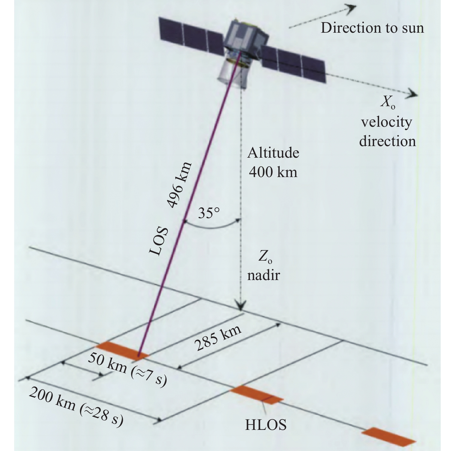
大气动力学计划(Atmospheric Dynamics Mission, ADM)是由欧洲航天局(ESA)在1999年提出执行的四个地球探索者核心计划中的一个,旨在弥补当前全球观测系统(GOS)和全球气候观测系统(GCOS)在风廓线分析方面存在的缺陷,从而改进全球三维风场分析,帮助众人理解影响大气动力学和全球大气运输、气溶胶、能量、水以及化学物质传播,进一步推动全球数值天气预报精度的提高及气候研究的发展[3]。由于技术原因,发射时载荷的工作方式和卫星轨道高度等参数设置和最初计划提出有所不同,最初参数设置可参照文献[3],卫星概念的示意图见图1。

Figure 1. Concept view of the Aeolus[3]
-
由于卫星的研发工程量和耗资巨大,ESA在研发过程中主要通过搭建模拟系统进行参数模拟,设计载荷的机载原型A2D进行多次机载实,从而模拟在卫星运行过程中可能出现的各种问题。
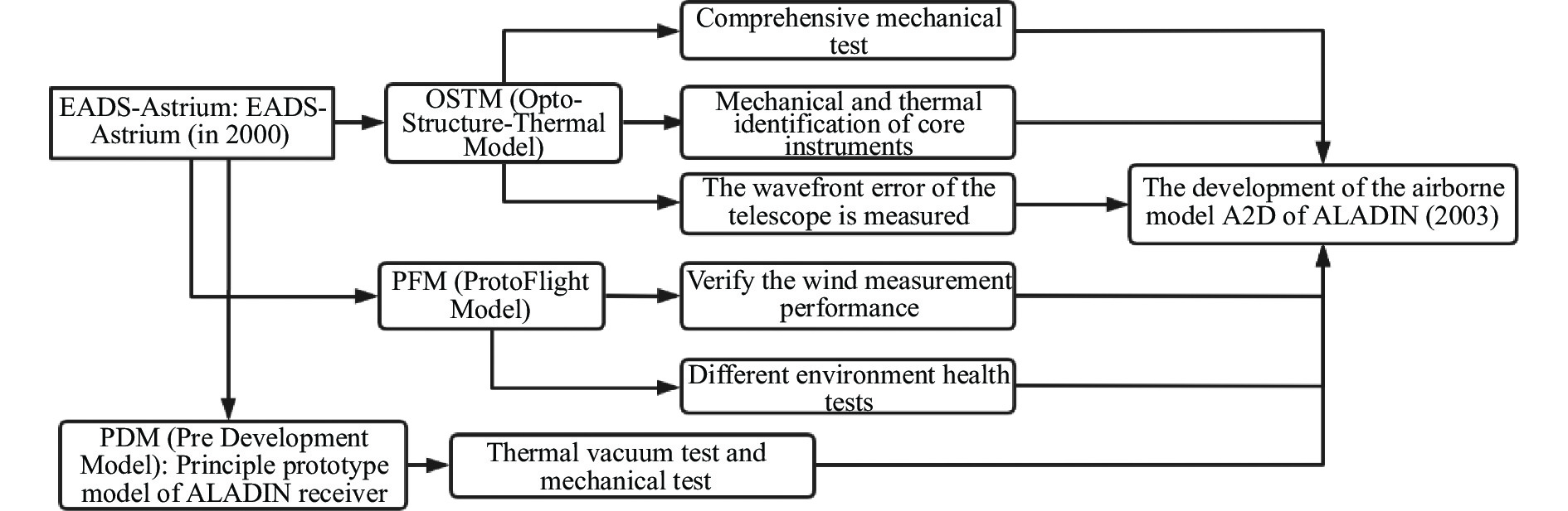
自2000年起,欧洲宇航防务集团下属的阿斯特里姆公司(EADS-Astrium)联合欧洲30多家公司共同对载荷ALADIN进行研发[10]。为了降低开发风险的同时保证仪器开发的时间规划合理,开发了两种仪器模型:OSTM(Opto-Structure-Thermal Model)和PFM(ProtoFlight Model),同时采用PDM(Pre Development Model)进行进行部分测试,主要测试流程见图2[11-12]。2007年,Astrium完成了对望远镜的制作和测试,并对发射机的激光二极管、接收机中的前置光学元件进行了环境条件测试、稳定性测试等,具体内容和结果可以参考文献[13]。
ESA用于进行机载试验的仪器A2D和卫星仪器参数的比较见表1[14],其与卫星载荷的主要区别在于望远镜、发射和接收光学器件以及激光发射器的工作方式。
机载试验还携带了2 µm的多普勒测风激光雷达(Doppler wind Lidar, DWL),用于对A2D的观测结果进行验证。发射前进行的6次机载试验(表2)[14-18]对各种大气场景(无云晴空、不同云类型或气溶胶、海面和陆地)进行大气风廓线观测,以测试、验证、优化观测数据质量的控制算法,评估视线方向风速的测量误差[12-13],得出了对检索算法和校准策略的改进,提出了未来验证活动中对于仪器的操作建议,优化了响应校准文件,预测了可能出现的误差来源,如背景光噪声等[18]。
2001年,ESA开发了ADM-Aeolus仪器的直接探测激光雷达模拟器,并实时纳入实际的ALADIN最新设计,该模拟器同时用于验证A2D仪器[19]。该模拟器提供了在不同大气环境状态下辐射传输特性、风速测量性能以及风速反演算法改进的依据。该模拟器的特点是具有15 m的垂直大气层分辨率[14-18]。
Item ALADIN A2D Transmitter Nd:YAG, tripled, diode-pumped Wavelength/nm 355 Operation Burst-mode Continuous Repetition rate/Hz 100 50 Energy per pulse/mJ 150 70 Telescope/m 1.5 0.2 Receiver FOV/µrad 15 100 Nadir angle/(°) 35 20 Altitude/km 408(320) 10 Table 1. Differences between ALADIN and A2D instruments[14]
Year Equipments Results October 2005 A2D Flying at an altitude of 8 to 10 km for about 4 h, the laser single pulse energy is only about 20 mJ and does not provide stable single-frequency operation[14-15] November 2007 A2D and
2 µm DWLThe number of photons in the analog signal on the Rayleigh receiver differs from the measured value by a factor of 2.5 to 4[12] 2008 A2D and
2 µm DWLAt altitudes between 4 and 17 km, the difference in the number of electrons between the simulated signal and the actual measurements is a factor of two[13] 2009 A2D and
2 µm DWLThe systematic and random errors of Rayleigh channel are −0.7 m/s and 1.9 m/s, respectively, and those of Mie channel are 1.1 m/s and 1.3 m/s, respectively[16] 2015 A2D and
2 µm DWLConfirm the performance of A2D and the expected calibration applicability of Aeolus satellite, and further improve the satellite wind profile inversion algorithm and correction file[17] 2016 A2D and
2 µm DWLShow the wind observation dataset in dynamic complex scenarios, such as strong wind shear conditions, to prepare for Aeolus data calibration and validation[18] Table 2. A2D validates the activity
-
Aeolus卫星于2018年8月发射升空,其携带的大气激光多普勒仪器ALADIN是一种在紫外光谱区域(355 nm)工作的直接探测多普勒测风激光雷达。回波信号进入接收系统中的鉴频器,通过检测多普勒频移量来进行风速反演:
式中:v为风速;
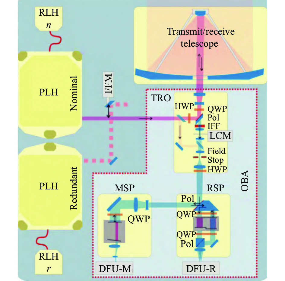
$ \lambda $ 为发射波长;$ \Delta f $ 为多普勒频移。激光雷达的发射方向与卫星运行轨道最低点的垂线成35°,与卫星轨道成90°,可以测量沿运行轨道区域刮过的风的东西向水平分量。为了提高信噪比,卫星最终运行轨道高度为320 km。轨道升交点选在晨昏轨道,可以提供最多的太阳照射和最良性的热环境,同时激光雷达指向夜间侧进行测量以减小背景信号噪声。接收器通过分析后向散射信号的多普勒频移和接收时间,从而确定不同高度的风速。ALADIN仪器整体上由三个主要元件组成:激光发射器、组合的Mie和Rayleigh后向散射接收器组件和直径1.5 m的卡塞格林望远镜[20-21]。具体的系统示意图见图3[22-23]。
Figure 3. Optical architecture of ALADIN[22]
-
ALADIN的激光器是二极管泵浦Nd:YAG激光器,将1064 nm基频光三倍频获得355 nm的紫外脉冲激光,单脉冲能量为80 mJ,具体细节可以参考文献[24]。与计划不同的一点是,由于激光器技术的进步,卫星最终确定的工作模式是连续发射脉冲,频率为50.5 Hz,而不是初始计划提出的7 s脉冲发射和20 s的突发型工作间隙的方式。
ALADIN的望远镜直径为1.5 m,用于收集来自大气的后向散射信号,虽然望远镜体积很大,但它由轻质陶瓷材料制成,因此质量仅为55 kg[24]。
ALDIN的测风技术使用了两种不同的鉴频技术,分别为条纹技术和双F-P(Fabry-Perot)鉴频器,用于计算Mie散射和Rayleigh散射的多普勒频移量。Mie散射通道的接收机由分辨率为100 MHz(相当于18 m/s)的Fizeau干涉仪组成。由于Fizeau干涉仪里两块带有楔角的平板,当气溶胶回波信号进入接收机,不同频率的光会在楔形平板的不同位置产生干涉,并产生干涉条纹。频率的偏移会导致干涉条纹偏移,干涉条纹在Mie散射通道的ACCD(Accumulation Charge Coupled Device)探测器上成像,接收到的后向散射信号产生一个线性条纹,其位置与风速直接相关,风速由条纹的质心位置决定。
Rayleigh散射通道的接收机采用一个双通道的F-P干涉仪,半高全宽为2 GHz,自由光谱间距为5 GHz,大气分子信号进入接收机后,区别于常用的分光方式,回波信号先通过一个F-P通道,一部分进入ACCD,一部分反射并通过另一个F-P通道再进入ACCD,形成连续观测的双F-P。信号在ACCD上成像并进行信号强度的光电转换,不同频率的信号会使两个通道具有不同的信号强度,最后通过差分运算获得两个通道的信号强度比值确定多普勒频移,两个通道的具体工作原理细节可以参照文献[25]、[26]的仿真工作。Aeolus系统的具体参数如表3所示[27]。
Satellite ALADIN Telescope/Front optics Laser transmitter Mean altitude/km Slant angle at satellite Vertical resolution/km Primary mirror diameter/m Receive FOV/μrad Wavelength/nm Energy per pulse/mJ Repetition rate/Hz 320 35° off nadir 0.25-2 1.5 1 354.8 80 50.5 Mie spectrometer Rayleigh spectrometer Detection unit Fizeau useful spectral range/pm Fizeau FWHM/nm Filter separation/pm Filter FWHM/MHz Quantum efficiency Dark current/e−·(pixel·s)−1 0.66 67 2.33 1551/1531(direct/reflected) 85% 1.9 Table 3. Partial parameters of Aeolus[27]
-
Aeolus的数据分为L0级、L1级和L2级。每级数据包含不同的信息,具体细节可以参考文献[23]。其中,L1B数据为已经过充分处理和校准的数据,包括HLOS风、地面回波数据和产品质量数据等。L2级数据包括整合了经纬度信息的HLOS风数据,并使用从ECMWF(European Centre for Medium-Range Wea-ther Forecasts)的数值模型中获得的实际压力和温度信息对风速值进行误差修正。L2 C数据主要包含在ECMWF同化L2 B产品后获得的风廓线信息,包括Aeolus地面轨迹位置上的径向和纬向风矢量剖面,L2 C产品主要包含来自NWP模型的信息[22],典型的Aeolus的L2 B风廓线产品和L2 A产品见图4,其中从L2 B产品可以观察到副热带急流,从L2 A产品中可以观察到低层的尘埃流。
-
在Aeolus卫星成功发射后,作为全球第一颗测风卫星,需要对其返回的数据质量进行验证,任务要求如表4所示[23]。同时,任务要求必须在实际观测3 h内被地面站处理并提供给相关机构,如ECWMF[30]。
Aeolus数据产品自2018年到2022年已经发布了14个数据处理版本。在此期间,世界多个机构对Aeolus的 L1级和L2级数据进行了大量的验证工作[30-32]。Aeolus的公开数据中会对数据进行分类,分为Rayleigh_clear、Rayleigh_cloud、Mie_clear和Mie_cloud,通常由于Rayleigh_cloud和Mie_clear的数据质量过低,在进行数据同化和数据验证时原则上会将这两类数据舍弃。整体上Rayleigh通道数据量远大于Mie通道数据,但Mie通道数据整体质量更好。在数据未公开前的任务调试阶段,由于仪器漂移,校准文件缺乏正确性,Rayleigh和Mie通道之间存在串扰效应,发射能量低于预期值,接收器的光阑导致回波信号损失[33-37]等原因,L2 B数据的Rayleigh通道风数据的系统误差约为1.5 m/s,随机误差约为4.84 m/s,Mie通道风数据系统误差约1 m/s,随机误差约为1.58 m/s。数据公开后到2022年4月,Aeolus的L2 B数据在全球范围内的随机误差为Rayleigh通道约6 m/s,Mie通道约3.3 m/s[36,38],误差来源包括Rayleigh通道的校准缺陷、热像素的波动带来的随机误差等[39],部分验证活动及误差见表5。由于其数据在处理时忽略垂直风速,因此数据误差随季节、地理位置和升降轨而变化,同时数据误差也受到云的影响。
针对Aeolus的L2 B产品早期阶段出现的问题,ESA对数据集进行重新处理,同时对算法和处理器进行了改进,通过对F-P干涉仪的传输特性进行优化,联合地面测风数据以及ECWMF的大气信息对产品中的误差进行修正以控制产品质量[39]。在2019年6月ESA转换了激光发射器为FM-B,由FM-B激光器发射激光,将脉冲能量从40 mJ提升到67 mJ[27]。但之后的数据验证活动表明,数据质量仍然不够理想[35,39-40]。2019年6月,在第二次对L2 B数据集进行再处理时,对四个发射前没有预计到的风速误差来源进行了修正[41]。针对2021年的数据误差升高,ESA重新设置了N/P的数值,将Rayleigh的数据质量提高了15%[42]。
Parameter Mission requirements PBL Troposphere Stratosphere Vertical domain/km 0-2 2-16 16-20 Vertical resolution/km 0.5 1 2 Horizontal domain Global Minimum horizontal track data availability (before QC) 95% Precision HLOS component/m·s−1 1 2.5 3(3-5) Unknown bias (HLOS)/m·s−1 0.7 (Errors that cannot be eliminated by instrument correction and ground calibration) Probability of gross errors 5% Data availability, timeliness/h 3 Table 4. Aeolus data accuracy requirements[23]
Activities Rayleigh
/m·s−1(SD)Mie
/m·s−1(SD)WindVal III(2 µm DWL), 2018[34] 4.75 2.95 AVATARE, 2019[43] 5.27 3.02 De Haute-Provence, 2019[33] 3.2 - The Atlantic ocean, 2018[44] 4.84 1.58 RWP network over China, 2020[45] 4.2 6.82 Long-term validation in Japan, 2019-2021[46] 9.19(B12) 5.98(B12) Ground-based coherent Doppler Lidar network over China, 2022[47] 7.07 3.15 La Réunion Island and the Observatoire de Haute Provence, 2022[48] 6.49 - Table 5. Validation activities
-
早期的验证结果表明L2 A产品虽然能够检测到重要的气溶胶层,如矿物粉尘等,同时在无云条件下能够实现检索激光雷达比进行气溶胶分类,但是数据质量并不理想。L2 A数据在3 km以下会受到较大影响,产品整体上的后向散射系数β的值偏小,对于退偏气溶胶颗粒,β的误差达到30%[49-50]。基于检验出现的问题,ESA对L2 A产品算法进行优化,包括对两个通道接收机的辐射传输效率提出了新的校正方案,提出最大似然估计法代替原标准校正算法,对产品进行去噪优化等[29,51]。在2021年的长期试验中,L2 A产品依然存在2 km以下的β存在较大误差、数据受到云层干扰严重等问题[44]。
-
Aeolus数据在中国区域的可用性也得到了验证,2020年Aeolus的L2 B数据和我国的地基风廓线雷达网进行了比较,结果显示卫星数据和我国华东地区大部分地区的地基测风数据结果一致性好[45],同年进行的Aeolus数据和L波段的探空数据联合ERA5数据的对比结果也得到了类似的结果[52]。利用我国的相干多普勒测风激光雷达,针对卫星产品中边界层和大气低层对流层的数据进行了对比,结果显示上升轨道的整体误差小于下降轨道[47]。
-
Aeolus卫星从成功发射到返回风廓线数据,其数据应用主要于改善数值天气预报、大气动力学研究和污染物研究。目前ECMWF、德国气象局、法国气象局以及英国气象局在日常预报业务中同化[53]。星载数据提供了南半球、海洋、沙漠地区的风廓线数据,推动了对于热带地区、对流层上部和平流层的大气动力学研究[54-55]。
首先,Aeolus提供的全球三维风廓线数据为改善数值预报进度做出了很大贡献。ECMWF将Aeolus数据在业务中进行同化后,热带地区的位势风、矢量风的预报误差减少了约2%,南半球减少了2%~3%[56]。2020年,德国气象局同化数据后,全球范围的3 h短时预报效果在热带地区的预报准确度提高了5%~10%[57]。NOAA(National Oceanic and Atmospheric Ad-ministration)利用Aeolus数据对2019年预报情况较差的飓风Dorian重新进行路径同化预报,10天的飓风轨迹预报误差明显下降[58]。中期天气预报中心(NCMRWF)在统一预报模型中加入了2019年8月—11月的数据,对飓风Nisarga的路径和强度进行了研究,同化数据后模型模拟出的飓风直接位置误差的改善最大达到了75 km[59]。
其次,Aeolus的数据主要应用在大气动力学研究方面。2020年,德国亥姆霍兹研究协会联合维也纳大学的研究结果显示,卫星风数据改善了模型中关于赤道波相位和振幅的研究缺陷,改善了热带地区的降水和气旋的预报[60]。同年,能源与气候研究所也证实了Aeolus数据能够提供准两年震荡(QBQ)中段的全过程[61]。2020年7月,ECMWF联合德国汉堡大学的数据分析表明,Aeolus数据增强了对流层顶最强垂直切变区的特征,改善了垂直传播赤道波的表现[62]。
除此之外,Aeolus的风廓线数据结合L2 A的气溶胶产品能够对环境研究提供一定的参考。2020年,ESA发布了由Aeolus卫星和哥白尼Sentinel-5 P卫星联合观测到大西洋上空的沙漠尘埃状况,其中Aeolus数据提供了气溶胶层高度和垂直范围的信息,这有助于确定尘埃层行进的高度[63]。2022年1月,ESA联合ECMWF等机构评估了Aeolus风数据同化对撒哈拉沙尘向热带大西洋流出数值模拟的影响,证明了其数据同化对热带地区、地中海东部地区沙尘模拟产生了积极影响[64]。2021年3月,中国海洋科学院的另一项研究也证明了Aeolus数据可以很好地监测灰尘的传输路径和平流值[65]。
-
随着Aeolus卫星的在轨时间已经接近预计使用寿命,ESA和欧洲气象卫星组织(EUMETSAT)发布了未来的星载测风计划[66]。EUMETSAT的初始计划规划了后续任务为两三颗卫星,总寿命为10~15年,并计划在2029年发射第一颗卫星。Aeolus-2卫星的仪器开发的思路是最大限度地利用ALADIN的设计,包括保留仪器设计概念,并对于其已经出现的问题进行优化。Aeolus-2提出了新的任务要求(表6),目前ALADIN的仪器团队正在根据需求进行测试,预计将提高激光发射能量到125~150 mJ,同时评估望远镜单发和双发的配置以及发射脉冲的频率等[67]。有学者提出未来还可以考虑沿轨道(向后)或前后测量,从而提供两个水平风分量的信息,也可以考虑在一组星座中实现多个轨道的测量[68],从而获取更多的风廓线信息。
Aeolus Aeolus-2 Range of observation/km 0-20 0-30 Requirement/m·s−1 0-2 km: 1
2-16 km: 2.5
16-20 km: 3-50-2 km: 2
2-16 km: 2.5
16-30 km: 5Number of vertical bins 24 75 Vertical resolution/m 0-2 km: 250
2-16 km: 1000
16-20 km: 2 0000-2 km: 250
2-16 km: 500
16-30 km: 1000Horizontal resolution/km 87(Rayleigh)/10(Mie) 1-16:<100(Rayleigh) 10(Mie)
16-30:<200Wind range/m·s−1 ±100 ±150 Table 6. Comparison of Aeolus and Aeolus2 mission requirements[67]
-
虽然Aeolus是一个较为成功的测风试验卫星,卫星上采用了几个相对先进的技术,如连续双F-P鉴频系统,在Mie通道上使用Fizeau干涉仪作为鉴频器,使用了ACCD实现垂直方向数据分层和累加等,但其数据质量没有达到预取的效果,随机误差的均方根远大于原计划的0.7 m/s。主要的原因是发射后的激光能量只有50~65 mJ,远小于预期能量80 mJ并持续衰减,回波信号减弱,随机误差增大,虽然ESA及时地采取了一系列的应对措施,但这部分的误差仍然不可忽略。
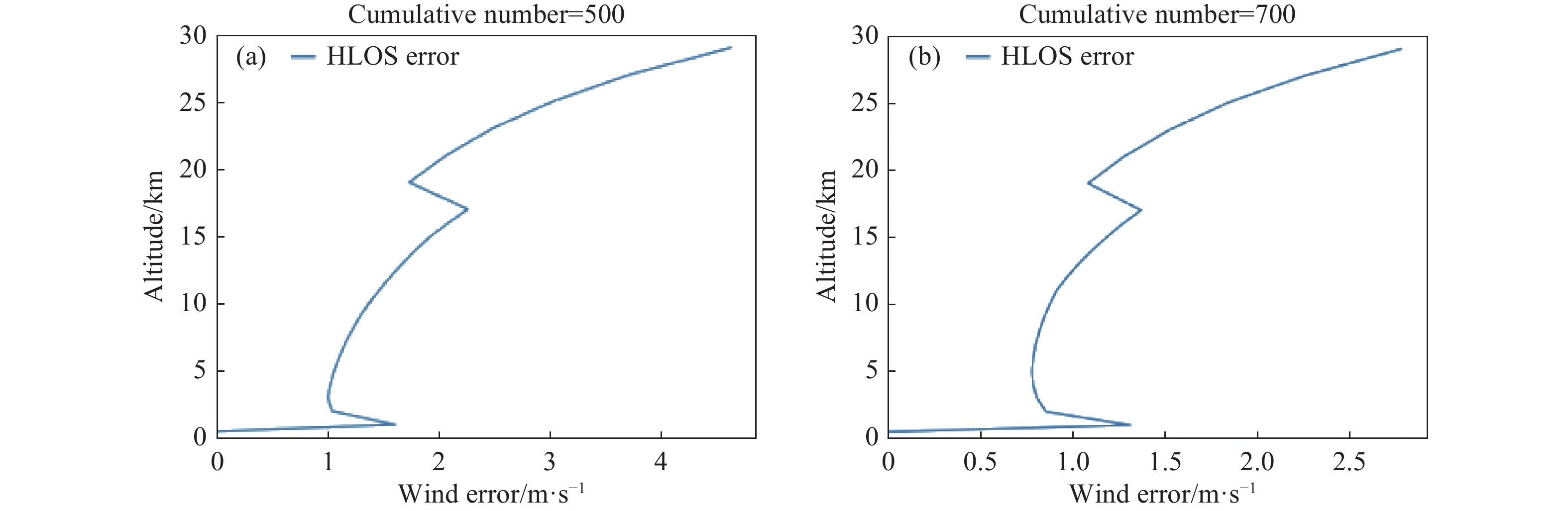
Aeolus的成功发射为我国的测风卫星研制提供了新的经验和思考,其设计方案的成功实施说明直接测风方案可以很好地应用于星载测风。基于这个考虑,参照Aeolus的工作原理,同时结合国内的研究现状,将ACCD替换为光电倍增管(阵列)(PMT),以增加激光雷达的信噪比。笔者对基于Rayleigh通道的星载测风方案进行了模拟,模拟参数和结果如图5所示。参照Aeolus的方案,选取大气分子和气溶胶分子灵敏度交叉点的半高全宽值作为双F-P鉴频器的模拟参数。图中可以看出,误差大小在垂直分辨率的高度改变时会有明显的减小(0~3 km分辨率为500 m,3~16 km分辨率为1 km,16~28 km分辨率为2 km),并随累计次数增多,风速误差整体减小,可以对0~30 km的大气进行探测。但在实际探测中,低层风速误差会由于气溶胶含量变化产生更大误差。Aeolus的数据证实了这种方案对于预报的正向影响,但其数据也有十分明显的缺陷,首先其数据量比较小,对于同一个观测点只能提供一个视线方向的风速,想要反演出完整的二维水平风场需要进行一系列的假设或配合模式预报数据,这也就意味着更大的误差。另外为了保证信噪比,其数据的垂直分辨率比较粗,所以不足以描述三维湍流的风,对于中小尺度的预报研究的参考价值不高[69]。

Figure 5. Cumulative wind speed errors with 500 pulses and 700 pulses simulation
目前,国际气象组织提出天气和气候应用所需的垂直分辨率在对流层约为1 km,平流层约为2 km,其中在规定的1~6 h覆盖范围内的水平风矢量精度要求为2 m/s[69]。要得到更加全面的风场信息或研究风场的日变化特征,需要改变激光的发射方向或改变轨道升交点、轨道高度,而升交点时间越接近12:00,背景噪声越大,想要保证回波信号的信噪比,就需要更大的激光发射能量[70]。考虑到风廓线观测要求的不断提高,以及我国对于星载测风的需求,未来我国在研制测风卫星时,可以从Aeolus卫星中得到几点经验:
(1)需要高脉冲能量和长期稳定的激光发射器,以提供更强的回波信号,实现高精度的风速反演;
(2)需要可以满足更高精度风廓线探测的高灵敏度、高响应率鉴频器,来实现更高的垂直和水平分辨率[1];
(3)需要更完善的激光器散热方案,这也是Aeolus发射一再推迟的原因,同时配合稳定的热控制系统和更加完善的针对热梯度误差的校正算法,以避免出现Aeolus望远镜上的温度梯度会造成的风速误差问题;
(4)直接测风技术可以实现星载测风,355 nm波长对于中高层大气分子测风具有良好的效果;
(5)研制一套合格的机载原型样机是成功的关键,同时需要进行大量的试验,在不同的地表类型、大气环境下进行观测试验,以完善星载载荷,尽可能估计发射后会出现的问题并做好预备方案;
(6) Aeolus的L1和L2处理器的处理速度很快,可以实现3 h内将数据处理并传输到世界各地的气象组织,这种高效的数据处理流程也是可以借鉴的内容;
(7)混合体制的探测方案弥补了单体制探测的不足,是未来的研究方向。
-
将激光雷达应用于星载是一项工程量巨大且耗费巨大的工作,需要评估最佳的方案,经过模拟试验、地基的原理样机验证、机载试验以及结合星载环境进行试验一系列流程才能成功发射[70]。
目前,国内多家单位都都致力地基测风激光雷达的研究,相关技术已经较为成熟,为未来星载计划奠定了技术基础。2006年,中国科学院安徽光学精密机械研究所报道了基于双F-P的1064 nm直接探测多普勒测风激光雷达,在对流层进行了三维风场探测[71]。2007年,中国海洋大学完成了我国第一台车载非相干测风激光雷达[72]。2010年,中原电子技术研究所研制了一套脉冲相干激光雷达,水平分辨率可以达到50 m[53]。2013年,中国科学院上海光学精密机械研究所提出了一种峰值功率超过千瓦的全光纤、发射1540 nm脉冲光的单频激光器,用于紧凑型远程相干多普勒测风激光雷达[73]。2019年,中国海洋大学提出了一种新的测风激光雷达数据同化方法,研究了地物对首都机场风速的影响[74]。
在星载激光雷达测风模拟工作方面,国内多家单位也进行了相关工作。其中,北京理工大学对星载相干测风激光雷达技术和可行性进行了全面分析,建立了通用型的星载相干测风激光雷达合成水平风速和风向误差计算模型并进行误差评估[75];中国海洋大学团队建立了碘分子测风的车载系统,设计了一套完整的星载测风激光雷达模拟仿真系统,对星载测量参数和误差进行评估[76]。中国科学院上海光学精密机械研究所自行研制直接探测多普勒激光测风雷达(DWL)原理样机,用于搭载临近空间飞行器,该样机发射波长为355 nm,接收信号利用双F-P进行鉴频测量多普勒频移,探测器使用PMT[77],同时持续开展了窄线宽大能量2 μm波段全固态激光器技术研究[78]、优化星载高光谱激光雷达反演气溶胶特性中的分光比设置等工作[79]。
除了Aeolus的直接测风方法,另外两种主要的方法为美国提出的混合体制测风激光雷达(Hybrid Do-ppler Wind Lidar, HDWL)[80]和日本提出的相干测风激光雷达(Coherent Doppler Wind Lidar, CDWL)[81]。HD-WL体制的探测方案中提出利用2 μm的相干探测技术进行低空探测,高空测量采用355 nm的直接探测,两个通道的观测形成互补,同时配备四个不同角度的望远镜进行测量,以保证对同一个探测点进行两次角度不同的测量来实现水平风场的测量。CDWL体制的探测方法是采用相干探测方法,配备两个角度不同的望远镜,对同一点的大气风速进行测量来合成二维水平风场。国防科技大学团队对三种不同的星载测风体制进行了综合的评估,结果表明,HDWL体制的方案可以获取最多的风场数据,其探测高度能够覆盖边界层和对流层,数据量是Aeolus方案的四倍,CDWL的两倍,同时保证较好的探测精度[68]。我国目前的研究方向是混合体制的星载测风技术,武艳伟等对于0~6 km使用相干外差技术,3~30 km使用双F-P直接测风技术的混合体制测风方案进行了详细的模拟和信号处理,证明了方案的可行性和先进性[82]。
-
文中回顾了国内外测风卫星的研究进程和发展状况,着重描述了ADM-Aeolus任务携带的唯一载荷ALADIN的原型机设计、地面测试和机载测试过程以及ALADIN的结构和基本工作流程,总结了Aeolus数据的长期验证结果。Aeolus的成功发射标志着星载测风时代的到来,它的成功也从实践的方面明确了星载测风的优势和必要性,证明了直接测风在星载测风方面的可行性。结合Aeolus的技术分析和数据特点,直接参照其方案并不适合我国的星载测风研究方向,相较之下,混合体制星载测风的优势更加明显,是我国未来主要的研究方向。目前,我国中国科学院上海光学精密机械研究所和北京遥测技术研究所等单位正在进行星载多普勒测风激光雷达的原理样机研制,相信未来我国的星载测风技术的发展会更加迅速[83]。
Review of the progress of Aeolus space-borne wind measurement lidar
doi: 10.3788/IRLA20220691
- Received Date: 2022-09-26
- Rev Recd Date: 2023-01-09
- Publish Date: 2023-05-25
Fund Project:
National Natural Science Foundation of China (42175145)
-
Key words:
- spaceborne /
- Aeolus /
- wind field measurement /
- Doppler wind lidar
Abstract:


 DownLoad: